

Mapping your world Since 2015
SIMPLE Aerial Solutions for the Mapping Community
Great solutions are almost intuitive, solving problems that nobody can anticipate. UNIFLI does just that – we’re hyper aware of all the pain points involved in drone data creation and management, and our services are seamlessly tied together to ease them.
About Us
DRONE DATA PROCESSING AND AERIAL MAPPING
THAT PUTS YOU IN FULL CONTROL!
It’s that simple. With UNIFLI, you can leverage the latest in technology to add an edge to your business.
UNIFLI was established in 2015 to help thousands of small, medium, and enterprise business owners use the power of drones to boost their operations and achieve sky high levels of efficiency with minimal interfaces and intervention.
Drones - Processing - Mapping - Deliverables
With your current fleet,
the sky's the limit!
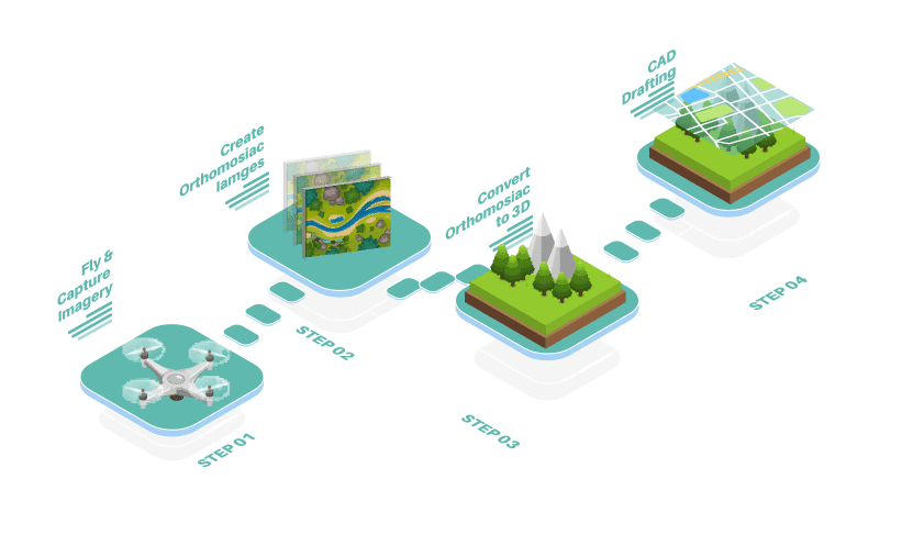
The power of control is in you hands. Unifli empowers the enterprise Pixelement processing engine to process geotagged drone photography into a multitude of data sets for real-time analysis.
Survey quality photogrammetry CAD is directly generated from your processed models for a streamlined workflow to increase quality and expedite delivery.
Our processing is compatible with most major drone brands, particularly with the expansive RTK/PPK emerging technologies. If you don’t yet have a survey quality drone, we can help bridge that gap too.
Freedom to choose the path of production:
This one stop shop is the solution to all your drone surveying problems!
The world of land surveying has changed, and how! Thanks to newer and more efficient technologies like drones and data capturing, it's much easier to survey land and collate, analyze and curate data in highly effective ways like never before.This one stop shop is the solution to all your drone surveying problems!
The world of land surveying has changed, and how! Thanks to newer and more efficient technologies like drones and data capturing, it's much easier to survey land and collate, analyze and curate data in highly effective ways like never before.This one stop shop is the solution to all your drone surveying problems!
The world of land surveying has changed, and how! Thanks to newer and more efficient technologies like drones and data capturing, it's much easier to survey land and collate, analyze and curate data in highly effective ways like never before.
Freedom to choose the path of production:

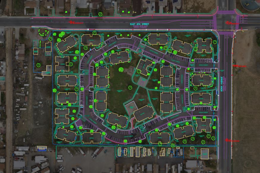
Professional Survey grade Photogrammetry CAD from your processed data with lightening speed.
Learn More
Unifli as a service, contract us to handle your aerial mapping needs from start to finish.
Learn MoreSupport
Exceptional support, now made easier
At UNIFLI, we believe in streamlined support systems that solve all your problems. Get first-hand support on everything drone related.
Drones have made it possible for many people to get an extraordinary aerial view. Enjoy seeing rare photography from a different view than you can get with traditional photos, and they can also be used in many unique ways. However, flying an actual drone takes skill and practice in order to maneuver the device to capture photography. A commercially flown drone requires an FAA Part 107 Certification. To legally fly a drone, there are certain restrictions you must adhere to in order to avoid penalties. A toy drone should not be confused with an actual professional model drone. A good course can help you master the art of flying a drone. It will allow you to work at your own pace and get a better understanding of how to successfully control your drone. UNIFLI can assist your drone workflow skills to the next level.